|
Reported Crop Circles for the State
of Arkansas-
Peach Orchard, Clay County (May 26, 2004)
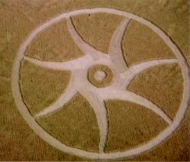
The formation was found by a crop-duster while spraying a nearby field. The formation measured 166' in diameter This formation appeared near the 2003 Knobel, AR formation, and at approximately the same time of year. The formation was barely visible from nearby roads.

The farmer found no obvious signs of human involvement (no footprints and no broken plants), and pointed out that the field had been planted by drill with the plants very close together. He did find animal tracks, particularly deer, along a nearby drainage ditch.
Researcher JoAnne Scarpellini’s visual examination of the plants revealed no expulsion cavities and only minimal apical node elongation. No magnetic particles were recovered by a ‘magnetic drag’ technique.
The lay of the crop reportedly had moderate layering with 3 layers of crop flattened in several places. The direction of the crop in the 7 curved arcs was from the outside towards the center of the formation, flowing both under and over the lay of the inner flattened ‘ring’ around the standing center ring.. Two intact bird's nests were also found in the formation -one still attached to the wheat stalks. The second nest, from a tree-dwelling bird, was also found in the formation.
BLT, Inc. was involved in the investigation of the formation and reportedly had soil and plant samples collected.
Crop
type: wheat
Source and photos: BLT, Inc., Joanne Scarpellini
|
|
City
/ County / Date:
- Elkins-Elking, Washington County, AR (1955)
- [Unknown], (May 2003)
- Knobel,
Clay County
(June 8, 2003)
- Peach
Orchard, Clay County
(May 26, 2004)
- (Northeastern) [*Location withheld by BLT, Inc.],
(June 14, 2007)
|


